


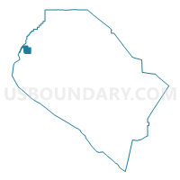
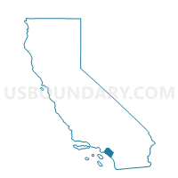
Voting District 21361, Orange County, California
About
Outline

Summary
| Unique Area Identifier | 536609 |
| Name | Voting District 21361 |
| County | Orange County |
| State | California |
| Area (square miles) | 3.46 |
| Land Area (square miles) | 3.41 |
| Water Area (square miles) | 0.05 |
| % of Land Area | 98.51 |
| % of Water Area | 1.49 |
| Latitude of the Internal Point | 33.79524870 |
| Longtitude of the Internal Point | -118.05930480 |
Maps

Graphs
Select a template below for downloading or customizing gragh for Voting District 21361, Orange County, California


Neighbors
Neighoring Voting District (by Name) Neighboring Voting District on the Map
- Voting District 21306, Orange County, CA
- Voting District 21311, Orange County, CA
- Voting District 21321, Orange County, CA
- Voting District 21326, Orange County, CA
- Voting District 21331, Orange County, CA
- Voting District 21336, Orange County, CA
- Voting District 21341, Orange County, CA
- Voting District 21346, Orange County, CA
- Voting District 21366, Orange County, CA
- Voting District 21367, Orange County, CA
- Voting District 21371, Orange County, CA
- Voting District 21376, Orange County, CA
- Voting District 21381, Orange County, CA
- Voting District 21386, Orange County, CA
- Voting District 21396, Orange County, CA
- Voting District 21551, Orange County, CA
- Voting District 21591, Orange County, CA
- Voting District 43468, Los Angeles County, CA
- Voting District 43753, Los Angeles County, CA
Top 10 Neighboring County Subdivision (by Population) Neighboring County Subdivision on the Map
- Anaheim-Santa Ana-Garden Grove CCD, Orange County, CA (1,648,519)
- Long Beach-Lakewood CCD, Los Angeles County, CA (569,100)
- North Coast CCD, Orange County, CA (366,151)
Top 10 Neighboring Place (by Population) Neighboring Place on the Map
- Long Beach city, CA (462,257)
- Garden Grove city, CA (170,883)
- Cypress city, CA (47,802)
- Seal Beach city, CA (24,168)
- Los Alamitos city, CA (11,449)
- Rossmoor CDP, CA (10,244)
Top 10 Neighboring Elementary School District (by Population) Neighboring Elementary School District on the Map
Top 10 Neighboring Secondary School District (by Population) Neighboring Secondary School District on the Map
Top 10 Neighboring Unified School District (by Population) Neighboring Unified School District on the Map
- Long Beach Unified School District, CA (510,940)
- Garden Grove Unified School District, CA (274,618)
- Los Alamitos Unified School District, CA (48,688)
Top 10 Neighboring State Legislative District Lower Chamber (by Population) Neighboring State Legislative District Lower Chamber on the Map
Top 10 Neighboring State Legislative District Upper Chamber (by Population) Neighboring State Legislative District Upper Chamber on the Map
Top 10 Neighboring 111th Congressional District (by Population) Neighboring 111th Congressional District on the Map
Top 10 Neighboring Census Tract (by Population) Neighboring Census Tract on the Map
- Census Tract 1100.12, Orange County, CA (5,012)
- Census Tract 1100.14, Orange County, CA (4,905)
- Census Tract 1101.14, Orange County, CA (4,828)
- Census Tract 1100.07, Orange County, CA (4,799)
- Census Tract 1100.01, Orange County, CA (4,467)
- Census Tract 1100.08, Orange County, CA (4,374)
- Census Tract 1101.06, Orange County, CA (3,577)
- Census Tract 1100.15, Orange County, CA (3,548)
- Census Tract 1100.05, Orange County, CA (3,124)
- Census Tract 1100.06, Orange County, CA (2,885)
Top 10 Neighboring 5-Digit ZIP Code Tabulation Area (by Population) Neighboring 5-Digit ZIP Code Tabulation Area on the Map
- 90630, CA (47,993)
- 90815, CA (39,733)
- 90808, CA (38,232)
- 90740, CA (23,729)
- 90720, CA (21,751)
- 92845, CA (16,333)